Map by Pedro Morais
The University of Texas Marine Science Institute (UTMSI) has expanded its coastal observing network with the deployment of a suite of offshore monitoring buoys that provide real-time environmental and oceanographic data to researchers, mariners, coastal managers, emergency planners, and the public.
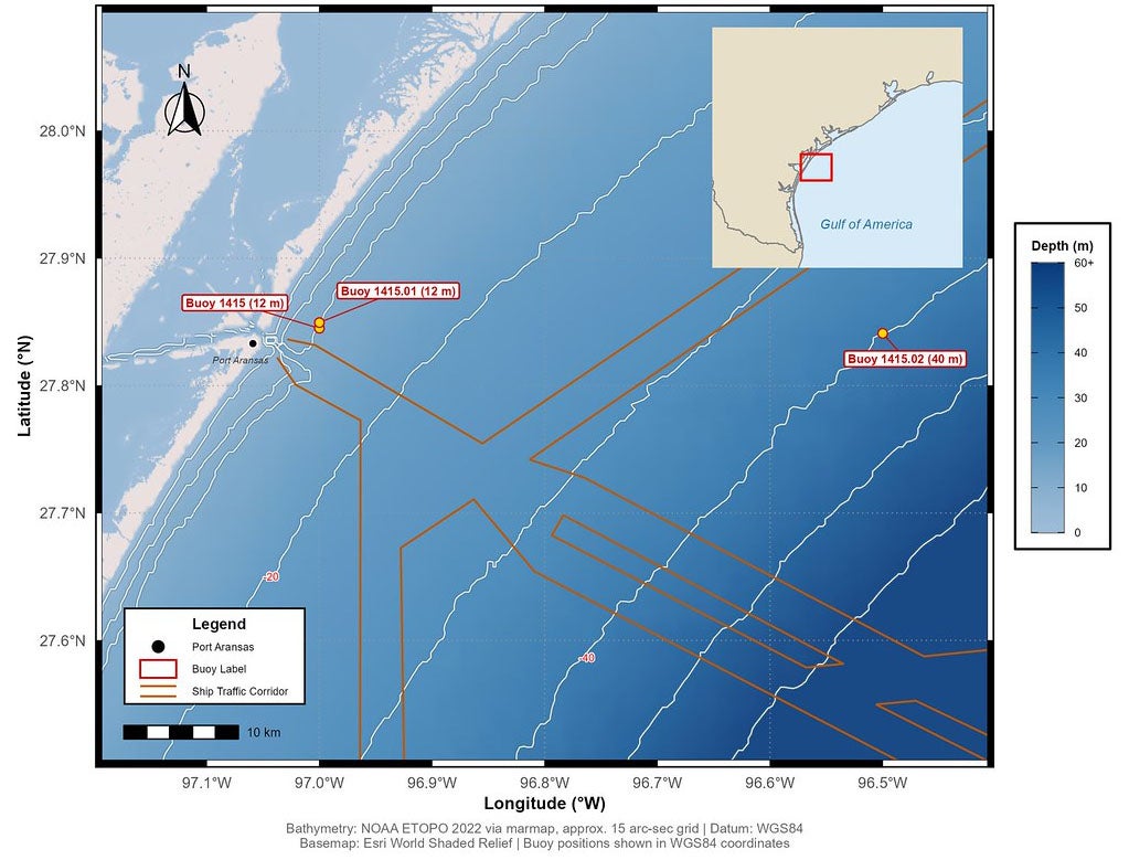
The network consists of three buoys strategically positioned from the nearshore environment to the continental shelf, giving researchers a more complete picture of conditions along the Texas coast.
Two buoys are located approximately 2.5 miles offshore of Port Aransas, north of the jetties, in about 12 meters (40 feet) of water. One buoy continuously measures environmental conditions, including waves, weather, and water quality. A second buoy combines environmental monitoring with a hydrophone, an underwater microphone that records ocean sounds.
A third buoy is located approximately 30 miles offshore in 40 meters (130 feet) of water and collects the same environmental measurements as the nearshore environmental buoy. Together, the nearshore and offshore stations allow researchers to compare conditions closer to shore with those farther offshore and monitor how waves, winds, and water properties change across the coastal environment.
Data are publicly available and updated every 30 minutes through the UTMSI website and associated dashboards. Measurements include wave height, wave period, wave direction, wind speed and direction, barometric pressure, water temperature, salinity, and dissolved oxygen. The buoy system also measures water temperature at three depths, salinity near the surface and seafloor, and dissolved oxygen within the water column, providing a more complete picture of conditions in Texas coastal waters.
One valuable addition is the collection of direct wave measurements immediately offshore of Port Aransas. Wave measurements support assessments of rip-current potential and are essential for navigation safety. The new UTMSI buoys complement measurements by a PORTS® NOAA buoy located off the South Jetty near the Aransas Pass.
These observations have applications ranging from boating and maritime safety to coastal research and management. Direct measurements of wave conditions can provide mariners, anglers, surfers, and offshore operators with a more accurate picture of local conditions. The data may also help inform decision-making during tropical storms, hurricanes, coastal flooding events, and environmental incidents such as oil spills by providing real-time information on changing ocean conditions.
For researchers, the buoy network offers new opportunities to better understand processes such as coastal circulation, nutrient mixing, sediment transport, fish and crab larval transport, and harmful algal bloom dynamics. The hydrophone buoy also adds another dimension by allowing researchers to "listen" to the Gulf. The underwater microphone continuously records sound and generates a sound-frequency spectrogram that can reveal biological activity, including spawning events of sound-producing fish such as red drum, spotted sea trout, and other species that communicate through sound.
"Real-time observations of our nearshore and offshore conditions are essential for understanding and managing our coastal environment," said Dr. Sharon Herzka, Associate Professor and Director of The University of Texas Marine Science Institute. "These buoys provide valuable information for everyone from scientists and emergency managers to fishermen, boaters, and coastal residents. By making the data publicly available, we're creating a resource that supports research, safety, and resilience along the Texas coast." Together, the three-buoy array provides a unique combination of physical, chemical, and biological observations, creating one of the most comprehensive real-time coastal monitoring systems on the Texas coast.
All buoy data are freely available through the UTMSI Currents and Weather website and associated dashboards:
Environmental Data Nearshore: SOFAR Environmental Dashboard
Environmental Data Offshore: SOFAR Environmental Dashboard
Underwater Sound Data: SOFAR Hydrophone Dashboard
Additional Conditions and Data: UTMSI Currents & Weather
The buoy network was supported through funding provided by the University of Texas through with Texas Legislature support and H-E-B. This network strengthens Texas' capacity to monitor coastal conditions, advance marine research, improve public access to environmental information, and support informed decision-making along the Gulf Coast.